


Maps for Public Institutions:
SmartMaps Ensures Data Privacy
Data security for public administration
and government agencies
Public administrations, offices, and government agencies are subject to particularly stringent data protection requirements. It is therefore essential to use a mapping service that fully complies with these standards.
SmartMaps is the ideal solution.
Benefit from a flexible maps solution
When it comes to using online maps and mapping services in public institutions and government offices, the following criteria are especially important:
Map Solutions for a Wide Range of Applications
Tailored features for public authorities
and government offices
Making Spatial Information Easy to Understand
A significant proportion of administrative tasks are location-based, including construction projects, environmental monitoring, traffic management, cadastral data, and crisis response. A mapping solution transforms complex data into a visual format, making it easier to support decision-making, communication, and public participation. For instance, building permit applications or land use plans can be clearly displayed on a digital map for staff, decision-makers, and citizens alike.
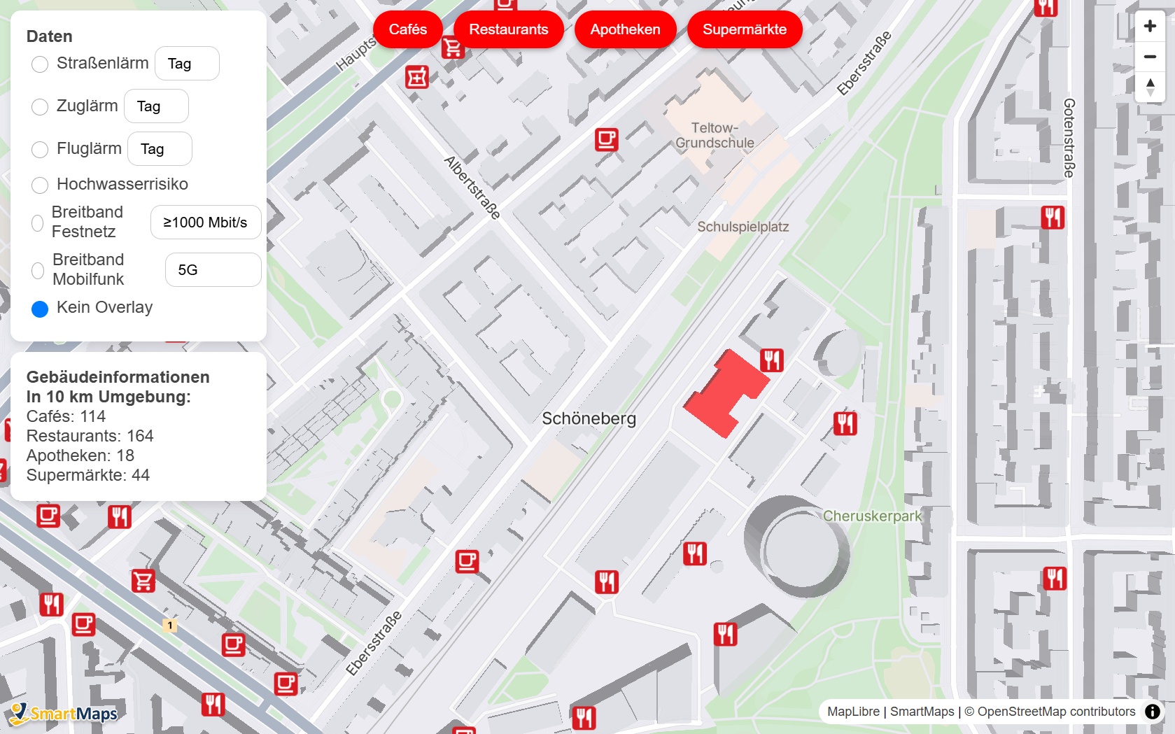
Flexibly Combine and Update Data
Modern mapping solutions enable the flexible combination and updating of various data sources, including geospatial data, statistics, aerial imagery, and real-time data. Open interfaces (APIs) and flexible map layers enable public authorities to show or hide data according to the specific use case. For instance, an environmental agency can combine pollutant measurements, protected areas, and weather data—updated daily and location-specific.
Security and Data Privacy
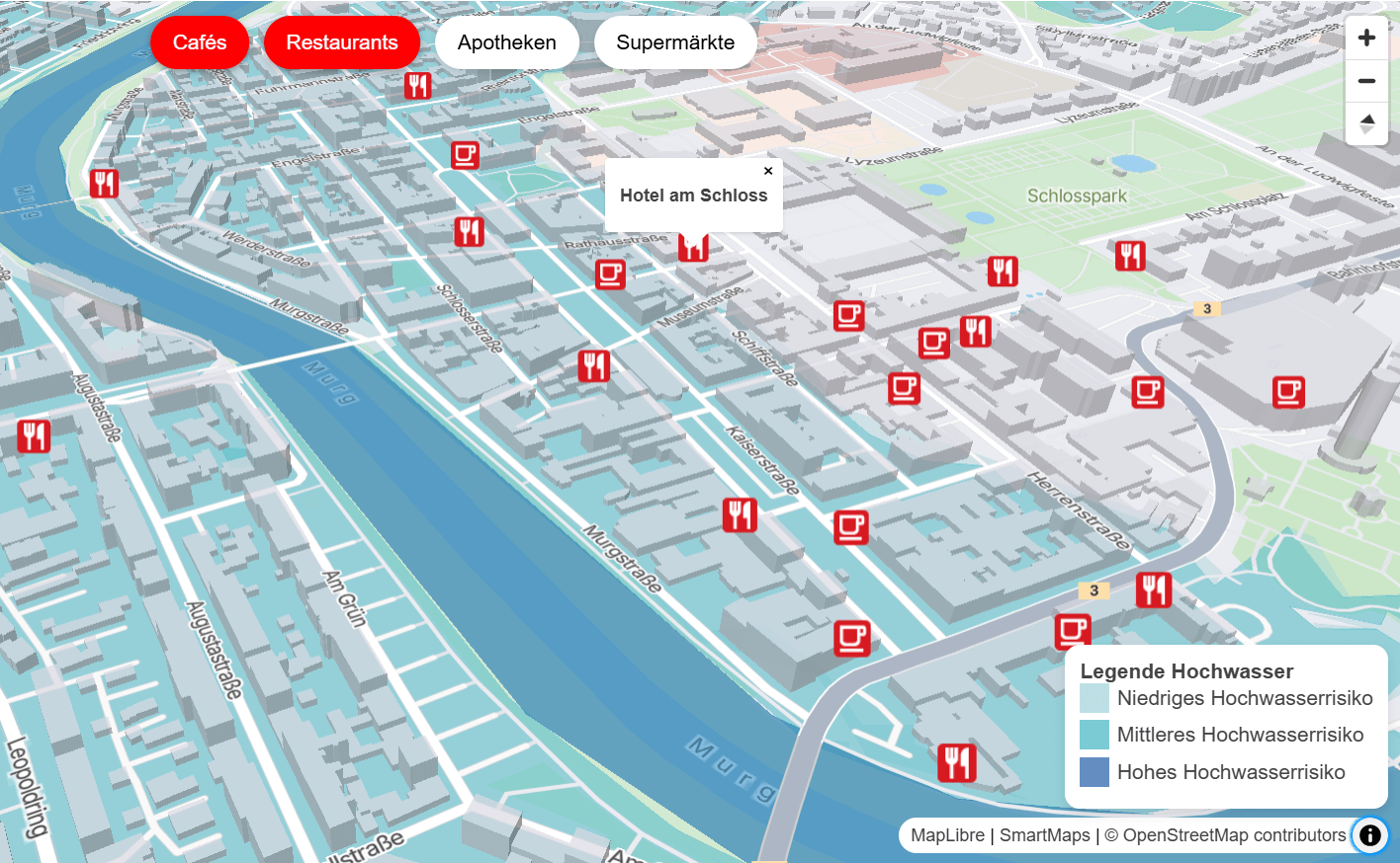
Public authorities are entrusted with the handling of sensitive data. Secure mapping solutions offer role-based access control, encrypted data transmission, and GDPR-compliant data storage. This is of particular importance when dealing with personal information, as in social services or cadastral offices. For instance, internal staff can view detailed ownership information, while citizens only see property boundaries.


More Efficient Processes and Collaboration
A central mapping platform can be used by different departments, or even across multiple public offices, without the need for data duplication. This approach saves time, promotes transparency, and improves coordination. For instance, building authorities, traffic planning, and urban development departments can all access the same map base to collaboratively visualise planning projects.
Crisis and Emergency Management
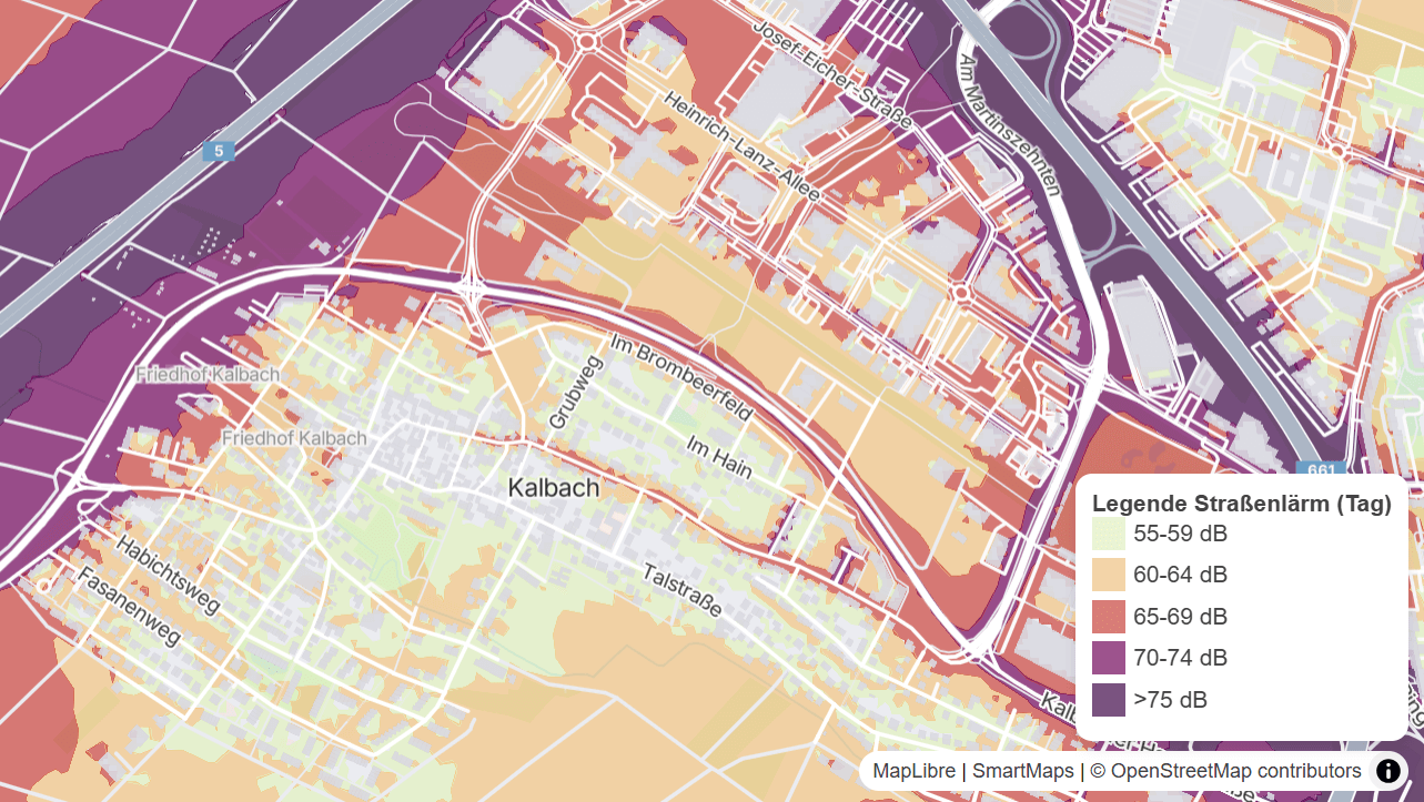
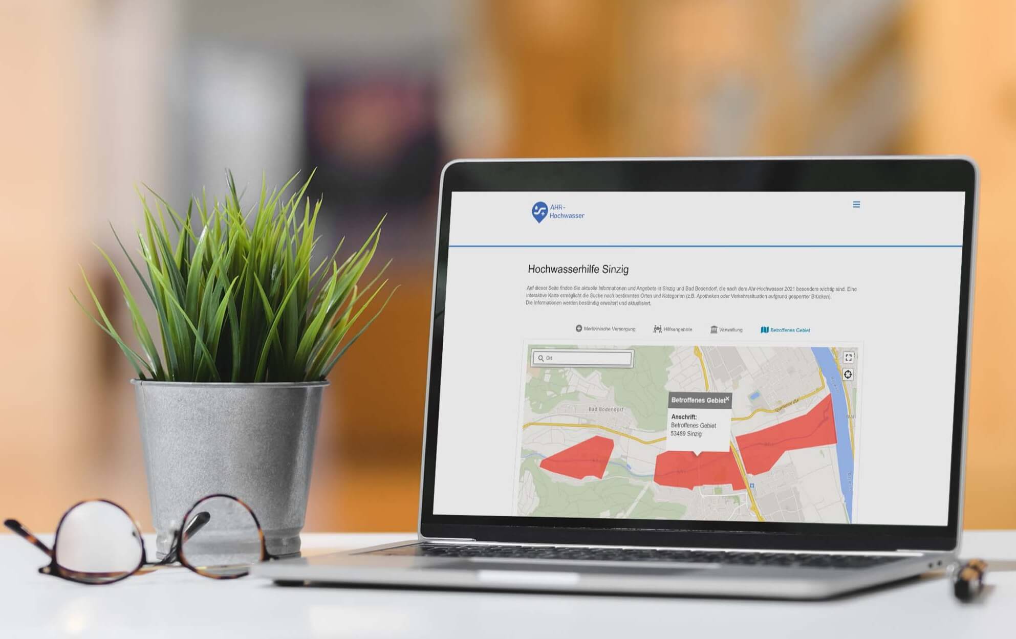
In emergency situations such as flooding, power outages, or evacuations, an up-to-date interactive map is an essential tool. Emergency teams can instantly identify affected areas, where resources are needed, and which routes are accessible. For instance, during periods of heavy rainfall, a municipality can utilise this system to monitor critical infrastructure, water levels, and at-risk buildings in real time.
Citizen Engagement and Transparency
Online maps make public administration more accessible: Citizens can access information and engage with local authorities on topics such as construction sites, green spaces, mobility services, and development plans. For instance, a public geoportal displays the locations of newly constructed bicycle pathways and facilitates direct feedback through a participation tool.
Get personal advice now
Which Mapping Services Are Suitable for
Public Authorities and Government Offices?
Balancing data privacy and functionality
Due to the specific requirements of public institutions, the selection of suitable mapping services is limited. Providers such as Google Maps, Bing Maps, or Apple Maps offer flexible customisation options, but the equally important issue of data privacy raises concerns. It is important to note that user data may be transferred to servers outside the European Union, which is not ideal for sensitive applications within the public sector.
One potential alternative is OpenStreetMap. This mapping service enables privacy-compliant usage. However, there are certain restrictions associated with the use of OpenStreetMap. For unlimited use, OpenStreetMap must be hosted and maintained on your own server, which is not always feasible for public institutions. Should special solutions such as custom visualisations be required, these must be developed independently, which demands in-house expertise and resources.
SmartMaps presents another alternative that combines data privacy and security with extensive customisation options and practical additional features — tailored to specific applications upon request.
Why SmartMaps Is the Ideal Solution for
Government Offices and Public Authorities
Personal consultation, accessibility, and GDPR-compliance
It is no coincidence that many public institutions already trust SmartMaps when it comes to mapping solutions. The new SmartMaps GL technology allows for customised map visualisations, including 3D building views, the enrichment of maps with additional information, and location, and radius-based maps. Features such as Geocoding, real-time Weather data, and Autocomplete ensure an optimal user experience.
SmartMaps is fully GDPR-compliant, ensuring optimal protection of user data. The software's accessibility features include customisable display modes and map profiles, which are particularly useful for people with red-green colour blindness. Enhanced contrast and adjustable text size improve map readability for all users.
We are committed to providing our clients with fast, comprehensive support and a dedicated personal contact. Discover our wide range of customisation options that are tailored to your specific needs and those of your users. These options are backed by 25 years of experience in the field.
"SmartMaps impressed us primarily with its GDPR compliance, which is a high priority for us; an unbeatable price-performance ratio; and the truly outstanding technical documentation."
Philipp Klusmeier, Head of eCommerce reifencom GmbH

"From the very beginning, we had the feeling that YellowMap meets our requirements and that we are in good hands. Not least because the company has been specializing in exactly this area for over 20 years and brought corresponding references. The team conveyed to us: The schedule is ambitious, but we can do it. The cooperation is thoroughly professional, very dedicated, and it also fits on a human level. We get quick answers and clear statements. There are firm commitments on both sides. In short: teamwork as you would wish for it!"
Laura Peters, Team Lead Digital Marketing OTTO-CHEMIE
"For all interactive Sparkasse locators within the Sparkassen-Finanzgruppe, we have been relying on the service of YellowMap AG since 2022. The migration of over 365 regional Sparkasse websites and our central portal sparkasse.de to the GDPR-compliant map platform SmartMaps was easy, and we benefit from cost savings compared to our previous provider. We and our Sparkassen are enthusiastic about the new map solution, which is hosted on German servers."

"In order to comply with the strict GDPR guidelines, we had to look for an alternative mapping solution to Google Maps. With SmartMaps, we found a user-friendly mapping platform that protects the privacy of our customers. The switch was easy and completed with little effort."
"In general, I absolutely loved your customer friendliness (assistance, quick problem solving, incorporating changes) and always having the feeling of having a contact person."
FAQ about SmartMaps for Public Authorities
Everything you need to know at a glance
I’m happy to help - how can I assist you?

Christopher Schmitt
Maps-Specialist
Tel.: +49 721 9638-125
geosolutions@yellowmap.de